
 |
 |

| Getting Started Key Words and Concepts Glossary Activities Recommended Resources Scuttlebutt |
Navigating the Mediterranean
Reading a map
Constitution navigated the Mediterranean Sea with the help of charts and maps like this one. Using the map, get your bearings and answer the questions below.
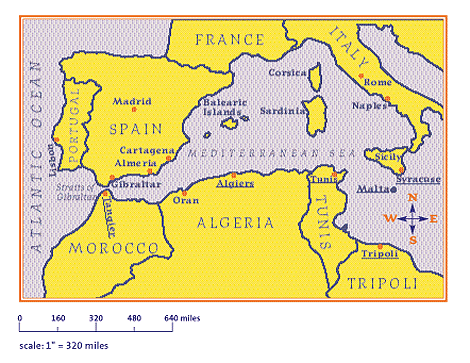
| 1. | Through what narrow passage did Constitution have to sail to reach the Barbary Coast? Straits of Gibraltar |
| 2. | What two bodies of water does this passage connect? Atlantic Ocean and Mediterranean Sea |
| 3. | France and Spain are in what direction from the Barbary coast? North |
| 4. | The American squadron’s base of operations was at Syracuse. On what island is it located? Sicily |
| 5. | How far did the Americans have to sail from their base of operations to reach Algiers? over 600 miles |
| 6. | Which Barbary state borders on two seas? Morocco |
| 7. | Describe how you would reach Sardinia if you were sailing from Tangier. answers will vary |
| 8. | (a) Which is closer to Naples, Oran or Tripoli? Tripoli (b) By how many miles? approximately 300 miles |
Have on Hand- photocopies of blank worksheet and rulers
Blank Worksheet (pdf)